2019 Camping Fees

Buffalo Point Campground: Sites with water, electric, flush restrooms, and showers will be $30, from $22, per night for up to six people.                                                                               

Steel Creek, Kyle’s Landing, Ozark, Tyler Bend Campground (all sites), $20, from $12 – $16,  a night for up to 6 people.

Steel Creek Horse Camp up to four stock animals are allowed.

  • Buffalo Point Campground walk-in tent sites (with water and flush restrooms, showers at Tyler Bend and Buffalo Point): from $12 and $16 to $20 a night for up to 6 people.               
  • Carver and Rush campgrounds: Primitive sites (with water, without flush restrooms) is $16, it was $12,  a night for up to 6 people.                                                                                                                                                                                                               
  • Buffalo Point and Tyler Bend Group Sites: The fee structure has been revised for group campsites to a flat rate of $50 per group per night (up to 25 people per site), it was $3 per person.
  • Erbie (including 5 group sites), Woolum, South Maumee, and Spring Creek will continue to allow free camping where no amenities are provided.

Pavilions fees will remain:  

  • $25 for the Ozark Pavilion for the day.
  • $50 for the Tyler Bend Pavilion and Buffalo Point Pavilions for the day.

There is a 50 percent discount for campsite fees for Interagency Senior and Access pass cardholders. 

Categories: History | Leave a comment

Buffalo River Trail Extended

More than 70 contributors to the Buffalo River Foundation’s Roberts Tract Campaign recently gathered at the trailhead on the South Maumee Road to hike two miles of the Buffalo River Trail (BRT).

Read More from the Harrison Daily Times – Click Here

Categories: History | Leave a comment

Lost Valley Update

PONCA – The National Park Service will close the Lost Valley Road and day-use area on Monday, Dec. 10, for a 10-week-long improvement project that will relocate a portion of Lost Valley Road, parking area, and trailhead out of the immediate flood zone of Clark Creek. The purpose of this project is to provide safe vehicular access to the Lost Valley Trailhead while minimizing adverse impacts to Clark Creek, the Buffalo River and the surrounding environment.

Lost Valley is a point of interest located at the western end of Buffalo National River near the town of Ponca. It is one of the most popular destinations at Buffalo National River, receiving about 77,000 visitors per year. The Lost Valley area features a heavily used hiking trail, picnic area, amphitheater, pavilion and restrooms.

Read the Full Article

Categories: Hiking | Tags: , | Leave a comment

Peak season is near for dazzling fall colors on Arkansas’ scenic byways

When Joyce Kilmer wrote “I think that I shall never see a poem lovely as a tree,” his often quoted and sometimes parodied verse failed to mention the captivating colors of fall foliage.

Making up for that omission each autumn is the Arkansas Department of Parks and Tourism, which provides ample online details updated weekly on the development of arboreal hues across the Natural State.  Travel Deals

The report, updated each Friday, indicates that the turning of the leaves is in progress but not yet at its prime. More rain would help foliage to brighten. The peak color periods are estimated to be as follows:

Click here for the full article

See a Eureka Springs Fall Foliage Webcam


Categories: History | Leave a comment

Buffalo River Partners Education Program

Buffalo National River Partners and Boone County Library present C.D. Scott, BNR Biologist: “Spring and Summer Visitors, Neo-Tropical Birds in the BNR and How IBA Designation will Help Them” Tuesday, Sept. 26, 5:30 p.m.

Categories: History | Leave a comment

Nice article in AY Magazine on the Buffalo River

The Buffalo National River: More than just a Canoeist’s Paradise

As a former outfitter on the Buffalo National River, I can fondly recall a number of memorable incidents over the years. Our modest operation was located at Silver Hill, not much more than a wide spot on U.S. Highway 65 a few miles north of Marshall in Searcy County, and we’d host guests from all over the country. My favorite goes back to the time a middle-aged couple from Louisiana walked through the front door and asked about a canoe trip. They’d arrived on a perfect spring morning in late May, a day with fluffy white clouds floating across a brilliant blue sky, temperatures in the mid-70s, and low humidity. And the water conditions were ideal.

Neither of our guests had been canoeing before and were eager to give it a try.  Read the full article

Categories: History | Leave a comment

TheCrazyTourist.com Picks Jasper, AR

TheCrazyTourist.com has selected Jasper, Arkansas as the Best small town to visit in the state of Arkansas.

Here is a bit of what they said:

Not always the first state to spring to mind when people think of the United States of America, Arkansas has many hidden gems that never cease to impress travelers. You should consider visiting this southern gem of a state with its majestic Ozark Mountains, famous healing springs and revolutionary Civil Rights movements that add a little bit of something special to what Arkansas has to offer. Whether you’re in search of a nature retreat or a bit of pampering and rest and relaxation, there are some out-of-the-way towns that still have that special combination of small town charm and Southern Hospitality that make them must-sees.

Jasper is located in Newton County on the Ozark Plateau. A formerly sleepy little town, the state decision to reintroduce elk to the nearby Buffalo National River Valley has breathed new life into the town.  Read the Full story


Categories: History | Leave a comment

Best hikes in Arkansas based on recommendations from Trails.com

The Natural State – a fitting nickname for Arkansas, which is known for its expansive and diverse wilderness areas that feature limestone caves, forests, rivers, hot springs, and mountains. With hundreds of trails to choose from, we’ve helped narrow your search by highlighting five of the best hikes in Arkansas based on recommendations from Trails.com.

Yellow Rock Trail
The Yellow Rock Trail leads hikers on a 3-mile trek up 300 feet in elevation to the top of Yellow Rock to offer the best panoramas of Devil’s Den State Park, including Lee Creek Valley and the surrounding Boston Mountains. Hikers pass huge boulders and interesting rock formations, steep bluffs, and forests of cedar trees walking the trail to Yellow Rock Overlook.

North Rim Trail
The North Rim Trail traverses 2.5 miles of the impressive bluffs of Mount Magazine, Arkansas’ highest point. This hiking trail runs along the mountain’s north rim through hardwood forest and across several creeks to Cameron Bluff Overlook Drive, which offers amazing views of the Arkansas River Valley and the Ozark Plateau.

Ozark Highland Trail
As of this writing, you can hike up to 218 miles of the Ozark Highland Trail (it will be 254 miles when complete), which runs through some of the most remote areas of the forested Ozark Mountains in northwest Arkansas. Taking this trail, hikers see wildflower fields, dozens of streams and seasonal waterfalls, and countless boulders, with points of particular interest being White Rock Mountain, Hurricane Creek Wilderness Area, the Buffalo National River, Marinoni Scenic Area, Dead Dog Bluff, and the Ozark Highlands National Scenic Byway.
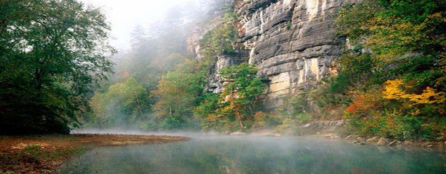
Buffalo River Trail
Hikers follow the Buffalo River for 37 miles on the river’s namesake trail, which varies in difficulty as it runs through untouched wilderness areas of the Buffalo River National Park. Explorers traverse everything from old homesteads and open fields to rocky canyons and bluff lines on the Buffalo River Trail, and the scenic views of the ever-changing river are hard to beat.

Lake Ouachita Vista Trail
You will be treated to spectacular sights hiking the Lake Ouachita Vista Trail, which runs for about 40 miles along the southern shore of Lake Ouachita. The Lake Ouachita Vista Trail traverses mountain slopes covered in mixed hardwood and pine forests, and it offers hikers many opportunities to see native wildlife and birds.


Posted thanks to https://www.civilized.life/articles/best-arkansas-hikes/

Categories: History | Leave a comment

Explore the Outside World

It’s the weekend and you have already planned to put off studying until Sunday evening. It’s beautiful and bright outside and everyone keeps texting you to see what your weekend plans involve…anything outside and less than a tank of gas away right??

Look no further! Eureka Springs is a short and stunning hour drive northeast of Fayetteville. 

On your drive over stop and check out Turpentine Creek a refuge for cats both big and small. 

On the north side of town, you will find Lake Leatherwood, AKA the perfect spot for all things outdoors: hammocking, camping, fishing, hiking, biking, taking natural light selfies, etc. 

In the midst of Eureka, you can find zip lining! 300 feet above the forest ground and spanning over 2,000 feet, a thrilling canopy tour awaits. Perfect for small groups this tour lasts two hours.

When you stop for lunch in town and as you check out all the funky stores, take some time to walk to all the natural springs, click here for a trail. Several restaurants in town are even built around the springs and little caves. 

So, you check out Lake Leatherwood in the morning or maybe you opt for zip lining, you then stop for a late bite-to-eat in town and take some time to look around. It’s early evening and time for you to check out the elk feeding between Ponca and Boxley along the Buffalo river. With the sunset casting it’s magical evening colors this provides the perfect photo opt to capture the best day out you’ve had in a long time!

 All within an hour of Fayetteville and you had no idea! So, text your friends back and let them know you have a plan everyone will love.

Overnight in Eureka Book a Hot Deal

Categories: History | Leave a comment

Fayetteville, Ar roadtrip through the Buffalo River Region

It’s the weekend and you have already planned to put off studying until Sunday evening. It’s beautiful and bright outside and everyone keeps texting you to see what your weekend plans involve…anything outside and less than a tank of gas away right??

Look no further! Eureka Springs is a short and stunning hour drive northeast of Fayetteville. 

On your drive over stop and check out Turpentine Creek a refuge for cats both big and small. 

On the north side of town, you will find Lake Leatherwood, AKA the perfect spot for all things outdoors: hammocking, camping, fishing, hiking, biking, taking natural light selfies, etc. 

In the midst of Eureka, you can find zip lining! 300 feet above the forest ground and spanning over 2,000 feet, a thrilling canopy tour awaits. Perfect for small groups this tour lasts two hours.

When you stop for lunch in town and as you check out all the funky stores, take some time to walk to all the natural springs, click here for a trail. Several restaurants in town are even built around the springs and little caves. 

So, you check out Lake Leatherwood in the morning or maybe you opt for zip lining, you then stop for a late bite-to-eat in town and take some time to look around. It’s early evening and time for you to check out the elk feeding between Ponca and Boxley along the Buffalo river. With the sunset casting it’s magical evening colors this provides the perfect photo opt to capture the best day out you’ve had in a long time!

 All within an hour of Fayetteville and you had no idea! So, text your friends back and let them know you have a plan everyone will love.

Categories: History | Leave a comment